The purpose of this trip, to Big Bend National Park in southwest Texas, was a 3-day wilderness canoe trip on the Rio Grande River, through the deep, scenic canyons along the Texas-Mexico border. Some land-hiking was also done before and after the canoe trip to complete the week of adventure.
 The drive from Houston to Big Bend is about 10 hours, and since I depart Houston on Friday afternoon, a good stopover point for the night is Seminole Canyon State Park, on Highway 90, just west of Del Rio, which is about six hours from Houston. There, I joined up with Louis Aulbach and Dana Enos to camp for the night.
The next day we caravanned to Big Bend, which is an additional four hours of westward driving. There, Natalie Wiest, Terry Burgess and Donna Grimes joined up with us in the campground, ready for the great canoe adventure.
River Day 1

|
| Photo by Terry Burgess |
I've joined up with my five fellow participants, and here you see the caravan of canoes, from a unique perspective, headed for the river put-in site:
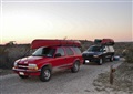
To start the trip, we unloaded our boats and gear at the river put-in near the tiny town of Lajitas. Then we drove our vehicles to a local outfitter shop and parked them on their lot, and hitched a ride in their van back to the river put-in location again. This kept the vehicles safe from break-in while we were away, and the outfitter was retained to pick us up three days later at an appointed place and time, downstream.
The canoe plan is for three days on the river. On Day 1 we will paddle about half the total 21-mile distance, which leads up to Santa Elena canyon. On Day 2 we’ll camp on the riverbank, hike to the top of a mountain, and relax. And we’ll finish up on Day 3 by paddling through the deepest canyon and popping out on the other side of the mesa.
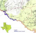 A map of the section of the Rio Grande River which we canoed:
The light-green area on the right is Big Bend National Park. The darker green area on the left is Big Bend Ranch State Park. And the white area in the middle is the towns of Lajitas and Terlingua, and private land.
The boats have been taken off the vehicles and placed next to the river, and we are tying down our loads of camping gear, sufficient for three days in the wilderness (photo below). Don’t forget the toilet paper!
Day 1 on the river – there are just "small" cliffs at this point (photo below).
Lunch break on a gravel bar, amidst grand scenery: We sit on our life vests for comfort amidst the rocks.
 |
|
 |
|
 |
| Loading boats |
|
Small cliffs
|
|
Lunch on rocks
|
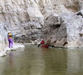
After lunch, we paddled some more, and then pulled over on the Mexican side of the river to view some ancient Indian pictographs on a cliff wall.
 |
|
 |
| John with pictographs |
|
Close-up view
|
What kind of creature is this with the puffy lips? Notice that there appears to be some liquid spewing forth from the animal’s mouth. One thought is that this was the way the Indians represented the noise the animal would make.
All the pictographs were marred with modern graffiti scratched on the rock.
|
| False sentinel |
Back on the river again: That peak up ahead is called "The False Sentinel". I think it's a "sentinel" because it stands straight and alone, and it's "false" because there is another very similar hill further along. And the 2nd one marks the beginning of the deep and narrow Santa Elena canyon. So this one is "false" because it doesn't have that significance as a landmark, and if you don't know that there are two of them, it could lead you to believe you're farther along the river than you really are.
We’ve reached “Entrance Rapids”, so-named because they mark the entry point into Santa Elena Canyon, which is the cleft on the far left in this photo. Here we stop for the night and make camp on a sand bar. Everyone spreads out and tries to find a piece of soft, flat ground upon which to pitch their tent. The camp tables are set up in a central location as a gathering spot for meals and relaxation. Canoes are turned upside down so that if it rains overnight, they won't fill with water
Relaxing in our collapsible camp chairs, facing the river, watching the moonlight dance on the rippled water, and enjoying good conversation. Seated here, from right to left, are: Dana, Louis, Natalie, Donna, and Terry (in the darkness).
 |
|
 |
| Camp |
|
Relaxing
|
River Day 2
On day two we just stayed put, camped on the riverbank, and hiked up to the top of a peak overlooking the desert and surrounding mountains and mesas.
We started our hike by going up the bottom of a canyon, headed up from the riverbed. That canyon came out on top of a mesa. Then you cross the mesa for quite a while, to get to the bottom of the peak. And then the real work begins...
One of the scary parts (left, below): This involved going sideways across an area with a lot of loose rock, at the top edge of a high cliff. Here you see Louis moving carefully. Concentration was required, as a slip and tumble over the edge would be fatal.
The final stretch: up some steep talus, and then hand climbing up about a 15-foot rock wall to the top (middle, below). This shows a good view way down into the river valley where we started, about 1,500 feet down. This is Louis and John getting close to the top.
We made it! (right, below: Terry Burgess, John Rich, & Louis Aulbach) Wow, what majestic scenery there was! That jagged zig-zag canyon down below cutting through the mesa is where we will enter Santa Elena Canyon with our canoes the next day. That canyon is 100 to 200 yards wide, up to 1,500-feet deep, and 10 miles long. Once you go in, there's no turning back.

|
|

|
|

|
| Atop mesa with cliff |
|
John, Louis |
|
Top of the mountain! |
Along the way, Terry found a nice fossil ammonite (below), an ancient snail-like sea creature, over 65 million years old.
Dinner time, salad is served: John, Louis, Dana, Donna & Natalie. Photo by Terry Burgess. It looks downright civilized.
 |
|

|
| Fossil ammonite |
|
Dinner time |
River Day 3
Now we’ve finished the day in camp on the river, and are ready to head back out onto the water again, following a pastel river sunrise (left, below):
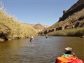
Entering the canyon, narrow and deep. There is no going back, now. (middle, below)
Narrower and deeper! Light barely penetrates down here, unless the bends of the canyon just happen to align with the direction of the sun, as it does up ahead around the corner. (right, below)

|
|

|
|

|
| Pastel sunrise |
|
Entering the canyon |
|
Dark canyon |
This is the tricky part of Santa Elena Canyon, where “Rockslide Rapids" lives. Part of the cliff sheared off and dropped house-sized boulders into the river, creating an intricate maze through which you have to weave, all the while being pushed along by a swift current. At this water level (3.8 feet/200 cfs at Lajitas), it was fairly tame – deep enough not to scrape the bottom of the boat (usually), but not so deep that the current was too dangerous.
Here is one web site to check the Rio Grande water level at Terlingua Creek:
Weather.gov
|
| Rockslide Rapid montage |
My panoramic profile of Rockslide Rapids (left), which is run from left to right: Ack! You could portage here, but it would be one heck of a lot of work climbing over steep, rough talus.
We had a river guidebook with us (written by Louis Aulbach), which shows an aerial view of this, taken from atop the cliff looking down, and we studied it the day before. I memorized the recommended route through these boulders, by reducing each move to a one-syllable word, coupled with mental visualization. So, if you ever find yourself approaching this maze in a canoe, just remember this: "left, right, middle, right, left". That's the secret!
I only crashed into a couple of rocks, but nearly everyone else did too, so I didn't feel overly clumsy. It's a good thing these plastic canoes are tough.
 Here I am running Rockslide Rapids! (Right, photo by Terry Burgess) Donna stands by ready with a camera and rescue rope. You enter from behind the rock on the left side of the picture, and have to make a 90-degree right turn, with the current pushing you towards that giant boulder. I made it, and only scraped a little bit. If you make a left turn instead of a right, you are then presented with a row of boulders called “the tight squeeze”, where the largest gap between them is only 36-inches wide – no one tried that path.
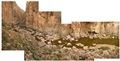
On the downstream side of Rockslide Rapids, we pulled over to the shoreline to take a short break, gather our wits, and see a few things there. Photo at left, below - Natalie examines an inscription carved into a boulder, by R.T. Hill, of the U.S. Geological Service, who first surveyed this canyon in 1899. Why does his “G” look like a “C”?
After that excitement in the rapids, it was time for a lunch break, on a beautiful soft grassy bank, inside the canyon walls (middle, below). Pictured: Terry, Louis, Dana, Donna, Natalie.
In the photo at right, below, Louis appears to be racing downhill at a steep angle!
 |
|
 |
|

|
Rock inscription
Photo by Terry Burgess |
|
Grassy lunch |
|
Angled strata
Photo by Terry Burgess |
When I first came around the river bend and saw this angled rock strata view on both sides of the canyon, I had to go "oh no...", because it looked like it was going to be log-flume bad. But actually, there was a weird optical illusion here. The angle of those striations in the layers of rock made it look like you should be rushing downhill at a high speed. But in fact, the water wasn't that fast here. The explanation is that the rock layers are angled upward, while your brain wants to assume that they are level, therefore making it just appear and feel like you are actually rushing downhill. Phew!
The light at the end of the tunnel, er... canyon (left, below). We're finally about to exit the 10-mile long Santa Elena Canyon, and pop out on the other side of the mesa into somewhat open country once again.
The take-out (middle, below): You pay an outfitter handsomely to bring a 4WD passenger van and canoe trailer out to a gravel bar to pick you up. We were right on time, as pre-arranged, and he was there waiting for us. Next, you unload all your gear and throw it in the van, and load all the canoes on the trailer. Then he drives you back to his shop where your personal cars are waiting for you.
My excellent group photo (right, below), which I arranged on the morning of Day 3, with a dramatic background:

|
|

|
|

|
| End of the canyon |
|
Take-out |
|
Group photo |
It took some doing to get everyone rounded up at the same time on a busy morning with everyone racing to pack their boats, and not be the last one holding everyone else up. Natalie is the butt of a lot of jokes for being short, so here she stands on a rock to gain some height and hopes that no one will notice. Busted!
From left to right, is:
- Terry Burgess, archaeologist.
- John Rich, mainframe computer geek.
- Natalie Wiest, librarian.
- Dana Enos, retired NASA engineer and locksmith.
- Donna Grimes, retired schoolteacher.
- Louis Aulbach, city records administrator.
Schoolteachers, librarians, computer geeks and paper-pushers: Not exactly the type of people you would expect to be rugged outdoorsmen! But these wonderful people are all highly experienced in the outdoors, and a true pleasure to spend time with on the river and in camp.