Bessie's Creek is a small waterway that I've had my eyes and mind on for several years. I keep driving over it in my local travels around west Houston, so as a canoeist, I'm always thinking; "I wonder if I can paddle that?" I've never heard of anyone paddling this creek. And I'm always looking for more paddling locations on the west side near where I live, as there are relatively few opportunities compared to the other parts of Houston. The west side has the Brazos River, and that's about it. The north, east and south sides have numerous waterways for canoe fun. So it would be nice to find additional places on the west side of town.
And so I set out one day to drive all the back country roads and do a detailed reconnoiter for public access locations and water conditions.
History
First of all, a little history lesson. Bessies Creek is sometimes also known as Best Creek, Best's Creek, or Besses Creek, It rises near Monaville in central Waller County and flows southeast for thirty miles to its mouth on the Brazos River, near Fulshear. It crosses an area of moderate to steep slopes surfaced by sandy loam and clay that support hardwoods and crops. The creek was probably named for Isaac Best, an early settler of Waller County.
Isaac Best was one of Stephen F. Austin's Old Three Hundred colonists, the original Anglo Texas settlers. Best spent his earlier years in Pennsylvania, Kentucky and Missouri, and finally came to Texas in 1824. Best received a land grant in what is now Waller County near Pattison, where he was a farmer and rancher. The creek which runs through his land is named for him.
References from The Handbook of Texas, by the Texas State Historical Association:
Bessies Creek
Isaac Best
And then as sometimes happens in history, people forgot the origin of the name of the creek and began to mispronounce it, and then to misspell it on maps to match the mispronunciations. Best's Creek became Bessie's Creek, and that is how it is shown on maps today. Isaac Best would be turning over in his grave if he knew.
Reconnoiter
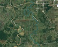
Now, where was I? Oh yeah, let's get back to the year 2016 and my reconnoiter of Best's Creek. The map on the left below, shows the location relative to Houston. As you can see, Best's Creek parallels the Brazos River on the east side, with the Katy Prairie as a watershed, and eventually flows into the Brazos River. The second map below zooms in to the segment of creek between I-10 and FM-1093, which is the widest and most paddleable. Some portions of it in the lower area are not much more than a drainage ditch. North of I-10 the creek is crossed by numerous farm and ranch dirt bridges, with culverts for water flow, which would make paddling a task of frequently dragging boats over the bridge berms. But the section south of I-10 and north of FM-1093 seems to average 100 to 200 feet wide, with nice views of surrounding prairie ranch land, mostly undeveloped - see map 3 below. But suburbia is racing that way, so go see it now before it's too late.
 |
|
 |
|
 |
| Location Map |
|
Road Map |
|
Aerial view |
Here's the internet link if you want to explore Best's Creek for yourself on your computer: Google Maps.
There is no water gauge for Bessies Creek, but I believe the water level is fairly constant and varies little.
As you can see on the road map, there are several road crossings of the creek, as both the creek and the roads zig-zag through the countryside. FM-1489 crosses it three times. So I spent some time driving the country roads to ascertain good access locations, and see what the creek looks like from a paddling perspective. A "good access location" is one where vehicles can be parked out of the way from traffic, a short distance from the creek, with shallow banks down to the water, and preferably grass rather than mud.
Legality
Allow me to get you side-tracked momentarily one more time before getting on with the trip report.
One of the big questions I had was if this creek was considered private property. One of the aspects of Texas river law says that if a waterway averages at least 30-feet in width, then it's considered navigable, and therefore is public property of the state of Texas. In other words, no private individual can own it and deny access to the public as private property. Well, this creek well exceeds that width in some places, but not in others. So what does that make it's legal status? That's hard to find out - there seems to be no list anywhere of what waterways are considered public or private. If anyone knows of such a list, please let me know.
References:
"Navigability"
"If A River Runs Through It, What Law Applies"?
| |

|
|
 |
| |
Fence line in water |
|
"No trespassing" |
Another fact that concerned me about private property is that there are numerous fences which extend down into the creek, as if the adjacent land owners are taking possession of the creek itself. But when I stopped and chatted with a man fishing off a bridge, he gave me a logical explanation for that. Several years ago the water level was low and cattle were walking around the ends of the fence lines and escaping from ranches. So the ranchers extended their fences down into the water to contain their livestock, and now that the water level is back up, you can still see the tops of those fences sticking out of the water surface. There is also a location where this is a "Private Property" sign out in the water, as if the land owner claims possession of the creek itself. But once again, that may have just been placed there during low water at what was at the time, the water line. The fisherman also said that he often sees small jon boats on the creek carrying fishermen, so that's a plus for the case for public water.
So I started to feel a little more comfortable that paddling the creek wouldn't be trespassing. And finally, some of the landowners along the creek have very nice properties, with beautiful houses, manicured river banks and fruit trees. Some of them have "No trespassing" signs along their waterlines, facing the water. Why would they need those signs if the creek itself was private property? It seemed to indicate that the creek was indeed public, and those signs were to keep the public from exiting boats onto their land. So those signs can actually be an indication that the creek is public. I finally decided that I would give it a try and see what happens, and hope that a county sheriff wouldn't be waiting to arrest me at my take-out.
Trip Report
Okay, on with the trip report, and I promise not to get sidetracked chasing down another rabbit hole.
My scouting determined that Hunt Road would make the best put-in location. It had ample parking space off the side of the road on the bridge right-of-way, very light low-speed traffic, a short portage just across the road to the creek edge, and shallow grassy banks. And it's located centrally north-south between I-10 and FM-1093, so you can paddle in either direction a good distance, and return. There is little to no flow here, so it's like paddling a lake. I'm into the creek and off and paddling, and didn't even work up a sweat or get my feet wet. I headed north with no goal in mind, just to paddle until I get tired, then turn around and return. I'd like to get as far north as I-10, but that was too much distance for me from the Hunt Road starting point.
The scenery was flat prairie on both sides, often tree lined banks, sometimes cattle, and very few dwellings in sight. The ranchers don't fence the water side of their property, letting the creek be a natural barrier to the cattle. But one rancher did fence the creek bank, and had a little bay dug under the fence to allow the water in to nourish his cattle. The road is alongside a good stretch of the creek, so there is frequent highway noise as cars pass by.
The cattle were the only "wildlife" I saw. No snakes, fish or mammals. Although I'm sure there are fish in there, judging by the amount of fishing tackle tangled in tree limbs at the bridges. Several egrets. And one blue heron, who exhibited the usual behavior of, when disturbed, flying further upstream so that you keep running into them over and over again. They're not as smart as kingfishers, who fly off to the side and head around you going back downstream, so that you won't bother them again.
 |
|
 |
|
 |
|
 |
| Put-in parking |
|
Put-in |
|
Scenery |
|
"Wildlife" |
There was little in the way of obstacles on the stretch I paddled, which was about three miles north, well past the FM-1489 bridge, where the creek takes a big meander to the west. Very few snags, no rocks. One obstacle was a dilapidated wooden footbridge across the creek. There were five spans, one of which was blocked by logs in the water, and a second which had a rope or cable draped across it. So eyeball it and choose another span to pass under. It's low enough that you just have to duck your head to get under it, but nothing drastic. Next up is the FM-1489 bridge, a modern concrete structure, perfect for swallows to make mud nests underneath.
 |
|
 |
|
 |
|
 |
| Foot bridge |
|
FM-1489 |
|
Swallow nests |
|
Skull |
The wind kicked up rather high on my return trip, which was unexpected. At one point it was blowing so hard that even paddling vigorously with my double-blade, I was barely making any forward progress. So I just pulled over to the bank and rested repeatedly, taking it a little bit at a time. So even though the total round-trip distance was only six miles, it felt like much more from the workout I got.
Along the way I found the skeleton of a cow at the waterline, and brought the skull back and placed it on a fence post at the Hunt Road bridge crossing.
The take-out was as easy as the put-in, and I still didn't get my feet wet. It's the only canoe trip I can ever remember where I never got wet feet. Best of all, there was no sheriff waiting to arrest me at the take-out. On the downside, there are no rapids for excitement, and it doesn't seem to be great for wildlife viewing.
I'm going to paddle this creek again. It's convenient, peaceful and easy. Next time, I'll start at Hunt Road and go downstream instead of upstream. Then reconnoiter some more by road to look for places to access other sections. It's something new, and it'll keep me busy for a little while...