Lazy, Bizarre Brazos
November 8th, 2012
by John Rich & Charles Zipprian
| |
 |
| |
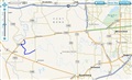
Location map |
On Thursday, November 8th, John Rich and Charles Zipprian undertook a trip on the Brazos River west of Houston. The chosen stretch this time was from FM-1093 to FM-1489 near Simonton, a distance of about 7 miles. The purpose was to get outdoors in the beautiful weather, go slow and easy, and spend time walking the gravel bars looking for fossils. And for me, to add another new river section to my ever-growing list of Brazos River paddling mileage.
But before starting with the river trip report, let me first attend to another matter.
~~~ A canoe launch sign does not a canoe launch make ~~~
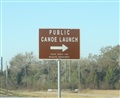
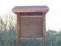
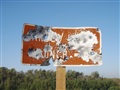
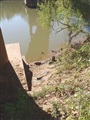
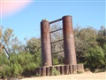
As you approach the the FM-1093 put-in bridge over the Brazos River, you see a brown sign announching the presence of a canoe launch site. Great! As you pull off the road and head under the bridge, you see another sign for canoe vehicle parking, about 100 yards from the riverbank. So you go past that, drive up to the riverbank, and unload your gear. Then run your shuttle, and return to the official parking area to leave your vehicle, and finally walk back to the riverbank. Well, there's many acres of parking much closer to the river, so I don't know what good that designated parking area does. But okay, it seems organized and someone put some thought into it. Walking from the parking area back to the riverbank, you pass an information kiosk, which is blank - no map under plexiglass, no canoe trail brochures, nothing. As you get to the riverbank, there is another brown sign on the right side announcing the canoe launch. At least I think that's what it is, but it's hard to read because someone has shot it so full of holes with guns that it's mostly illegible. And from the trail behind that sign it is hundreds of yards across a debris-filled sand bar to get to the water. Don't put your boat in where the arrow on the sign points. Use your own common sense and go to the left side, where it's a short gentle slope down to the water. That part was easy.
 |
|
 |
|
 |
|
 |
|
 |
| Road sign |
|
Empty kiosk |
|
Sign vandalism |
|
Put-in launch site |
|
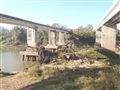
Take-out |
Now for the take-out canoe launch site at the FM-1489 bridge. There is only one way out of the river here, and that involves a muddy exit from the boat. From there, you have to lift your boat about five feet high in the air to get it on top of a concrete wall, which is the footing for the bridge pilings. Once atop the footing, you still have to climb a steep slope to get to the parking area. Charles and I are both big, strong men and after wrestling both boats up atop that ledge and then up the hill, we were spent for a few minutes. I sure wouldn't want to do it alone. Fort Bend County should be ashamed of themselves for advertising this as a canoe launch site. That implies that some kind of work has been done to accomodate the process of launching a canoe, and here you have absolutely nothing - it's a horrible access point.
So, in summary, there are NO physical improvements to the riverbanks which actually make canoe launching easy, like a gently sloping boat ramp, or stairs. All you get is a few signs, period. Hrumph. Fort Bend County hasn't actually done anything to facilitate the physical launching of canoes. The road signs sure are pretty though.
Okay, that ends my editorial portion of this trip report about the canoe launch sites, and now I'll get on with the more pleasant actual trip report.
~~~ The trip report ~~~
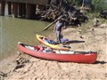
Since there were only two of us, the shuttle was slightly problematic. We had to leave our boats on the sandbar, unguarded, while we took both vehicles to the take-out, left one there, and returned to the put-in. So I used a steel cable lock that I keep in my bag of canoe tie-down straps to lock both boats to a large log. We figured that would deter a casual thief, and we wouldn't be gone very long.
After returning to the put-in, we packed the boats with our gear and shoved off. The best spot here is inbetween the railroad bridge on the left, and the road bridge on the right. A huge pile of debris has built up on the bridge pilings, and a sand bar has built up behind the log jams. That sand bar actually makes for a nice launch site. Just south of the current bridges are a pair of old railroad bridge pilings, just like those seen in other local river crossing locations. They are made of curved iron plates riveted together to make a tube, embedded in a concrete footing, and the hollow center filled with more concrete. This was the style in the late 1800's and early 1900's.
 |
|
 |
|
 |
| Boats locked to log |
|
At the put-in |
|
Old railroad bridge pilings |
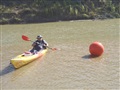
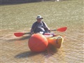
One of the unusual things seen on the river was a large orange ball that looked like a giant Texas-sized fishing bobber. It was washed up on a sand bar, so I pulled over to inspect it. It was made of thick orange plastic, hollow in the center, with a large eyebolt all the way through the middle. I tossed it back in the water and let it blow upstream in the wind, but it quickly become stuck in a logjam, where we left it. What was it used for? Where did it come from? A mystery!
 |
|
 |
| The buoy approaches Charles |
|
Charles snuggles with the buoy |
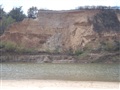
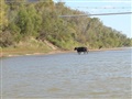
The river was its usual low-water self. Not very deep, not very fast, but deep enough to paddle without any problems. Some spots were low enough for cows to walk across from one side to the other, barely wetting their... um... bellies. There were few snags to cause problems, and the bluffs were interesting to examine the patterns of colored earth strata, the collapses that fall off the dirt cliffs towards the water, and the trees and fences fallling in on the top edge. There were two locations with pipeline crossings in the impressive suspension bridge style.
 |
|
 |
|
 |
|
 |
| River snags |
|
Bluffs |
|
Cow crossing |
|
Pipeline crossing |
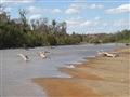
The bars were plentiful at the river bends, but consisted mostly of sand rather than gravel. Gravel is where you find fossils, so our fossil-hunting was limited. When we did find a gravel bar, only a few fossilized bones were found, and just a few pieces of petrified wood. Nothing noteworthy.
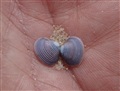
Wildlife was scarce for some reason, even the birds. We saw fish disturbing the surface as we surprised them in shallows. The few birds seen were egret, heron, kingfisher, ducks, hawks and buzzards. Animal tracks seen on the sand bars were deer, pig, coyote and raccoon. And there were a few strange drag marks like the belly of a large turtle, but with no footprints on either side. Hmmm. A couple of small, harmless snakes. One of the interesting animal sights was some pools of shallow water in the sand bars left behind by receding water. There were clams in those pools, and they leave behind lines in the silty bottom as they crawl along with their single foot. So there were random swirling lines in the pools. And there were also a lot of fresh, empty clam shells around the pools, surrounded by raccoon tracks, indicating that the coons come out at night and feast upon the clams in these pools.
 |
|
 |
| Purple clam |
|
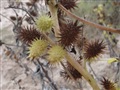
Burrs |
| |
 |
| |
Do not click to view this
photo if you will be
disturbed by the image
of a dead dog! |
As we approached the FM-1489 take-out bridge, from about a quarter-mile away I saw a pickup truck stop in the middle of the span. "What are they doing?", I wondered. A lady got out, peered over the side, waited for traffic to clear, and then threw something orange over the railing from about 30 feet above the water. Something black separated from the orange and plunged straight down into the water, while the orange thing fluttered down gently. Then she got back into her truck and drove off. About 10 minutes later we arrived on the scene in our boats and found a dead dog floating next to an orange blanket. I think the dog was already dead beforehand as it was somewhat stiff. Poor little guy. Why the heck dispose of it in the river like that? I was relieved it wasn't something like a human baby, but saddened to find this little dog.
It was a freaky end to an otherwise pleasant canoe trip.
River distance: about 7 miles. Time on the river: 6 lazy hours. We also probably walked several miles on the sandbars.
 |
|
John Rich
|